
The Making of Male’ Urban Mess: Part 2: 1930s — 1970s


This is the second of several articles on the architectural history of Male’ — the capital of the Maldives. The first article traces the settlement of Male’ island and the growth until the 1920s. This article outlines architectural developments from the 1930s to 1979. The first article may be accessed from the link below.
The first part of the essay covered the period from time immemorial to the 1920s. This present article deals with the period 1930s to the 1970s. In the period, there are two politicians who shaped the urban development of the Male’. One is Muhammad Amin who was active as a politician between 1943 and 1953 becoming President of the first Republic in 1953. The other was Ibrahim Nasir who was active in the period 1953 onwards becoming Prime Minister and later the President. It was Amin’s uncle who straightened the two intersecting thoroughfares of Male’ — Chaandhanee Magu and Majeedhee Magu — earlier in the 1920s as noted in Part 1.
Amin’s Era
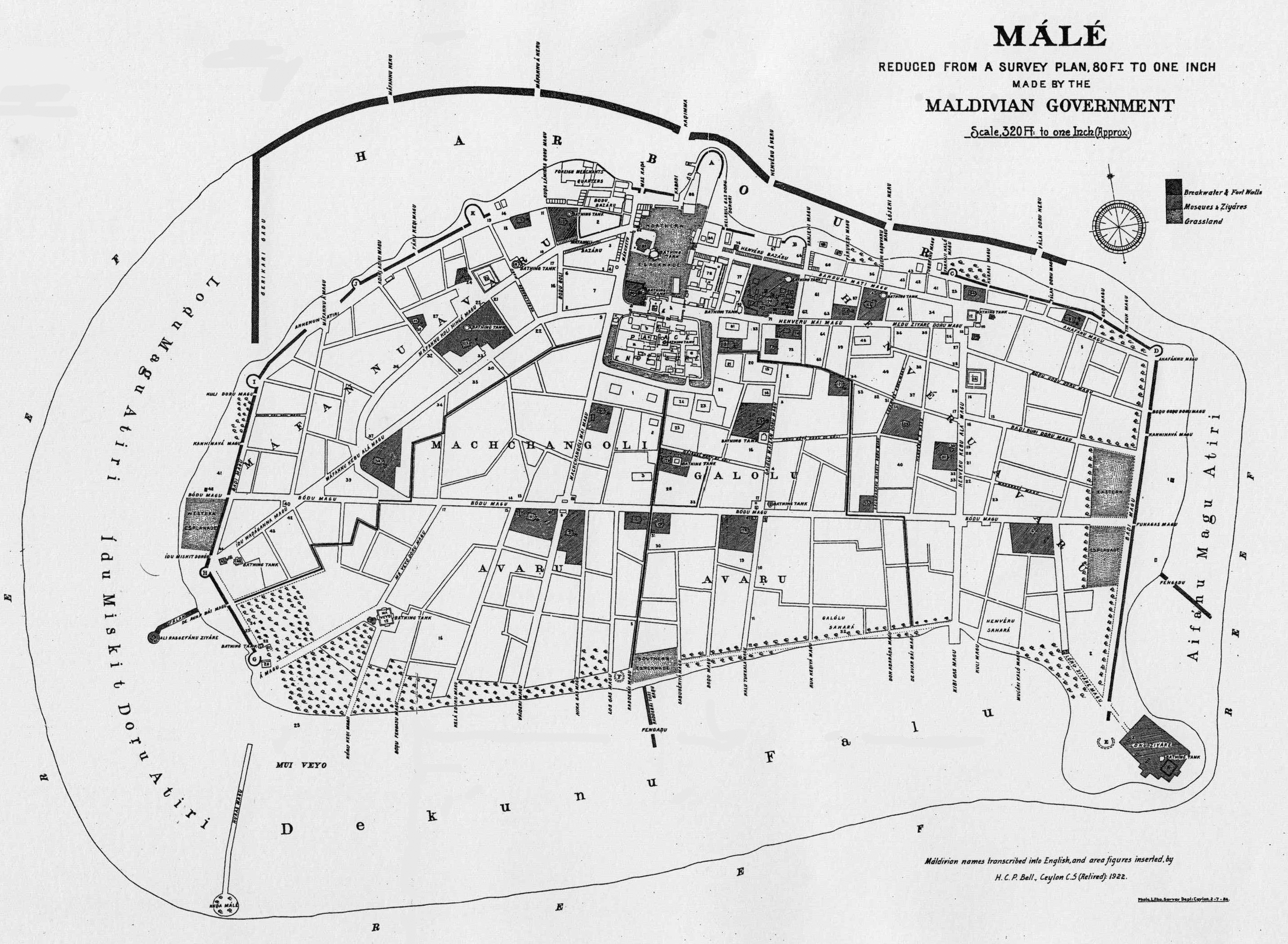
The street layout (island plan) remained more or less the same from the 1930s. Before the streets were straightened, most were quite narrow, many only 10 feet wide except for the streets through which the King and his entourage walked along during Ramazan for socio-religious events called Hithi. In hithi, the King and his entourage, with pomp and circumstance, paraded along these wider streets (known as Hichchah vadaigannavaa Magu) to pay homage to some mausoleums and mosques. These streets were not straight. The layout of the urban area did not change much during this period and remained true to the detailed map shown below.
The East to West distance of Male’ was longer than the perpendicular extents. For this reason, there were wider and longer streets in one direction than the other. Majeedhee Magu divides Male’ lengthwise and crosses Chandhanee Magu creating four quadrants. Most development was in the North East quadrant where all government offices, palaces and residences of most politicians were located. Apart from constructing significant buildings, some of which still stands, Amin’s other major contribution was building the boundary walls of homes facing Majeedhee Magu. The walls were built for the 1st of January 1953 — the date he became the President of the first Republic. The walls were built and plastered at government expense and had a different style from ward to ward. They were about five feet in height. The four wards are further subdivisions of the island from time immemorial: Maafannu, Machchangolhi, Galolhu and Henveyru.

Amin caused the street boundary walls on Majeedhee Magu to be lowered to about five feet. The walls were built and plastered by the government for the Republic Day —1st January 1953. The photo shows the style of boundary walls for Maafannu. Note the gate style. Next to the inside wall were flowering plants. In the distance is Eid Miskiiy.
Main structures of Male’ in the 1930s
Most of the people lived in thatched houses except for a very few. The most durable structures were the mosques, usually made of cut coral stone. Maldivians had discovered the manufacture and use of lime mortar for building homes a few centuries earlier. One of the earliest structures (and by far the largest) lime-mortar structure in Male’ was the defensive wall which surrounded three sides of Male’, interrupted by bastions at various distances. This defensive wall was built during the reign of King Mohamed Imaadhudheen I (alternatively known as Bodu Rasgefaanu) who was on the throne from 1621 to 1648. I have not come across older structures built with limestone dating to very early times.
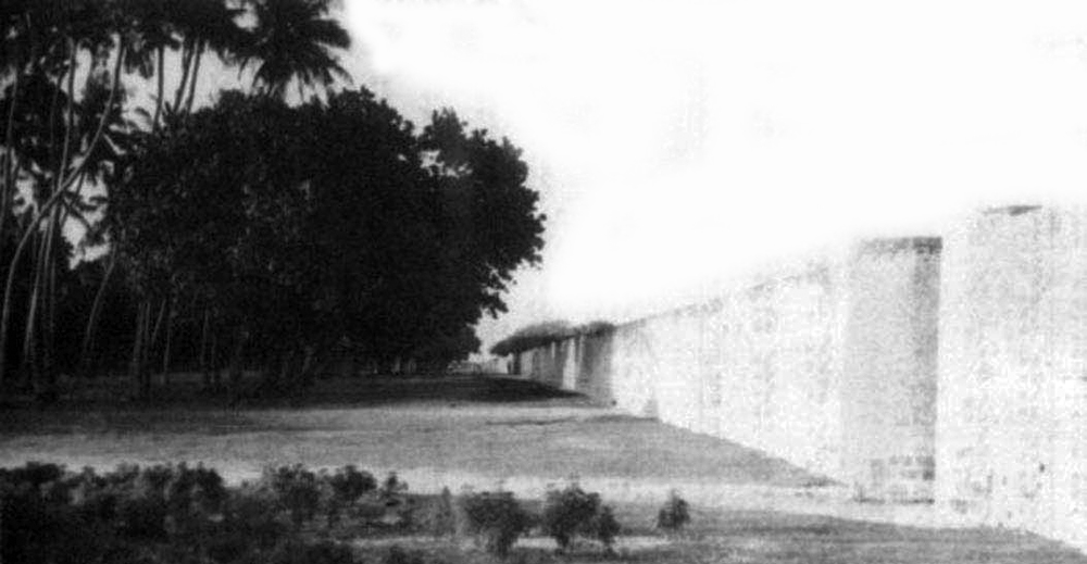
Bodufaaru was the defensive wall around three sides of Male’. This section is from the Eastern side. The wall was demolished in the 1960s without leaving any section standing. The height may be estimated to be a little more than 12 feet and the width at base a little wider than two feet. Eyewitnesses noted that the wall was about 15 feet high. There were narrow gateways and battlements at various points. Between the beach and the wall are coconut palms and other coastal vegetation. To protect the wall from shots, loose sand was poured on the outside with poles placed to retain them. The sand is called baadee in Dhivehi and baadee dhun’buri refers to the poles used for this purpose.
There were a number of notable government buildings built of lime-mortar and limestone (quarried from reefs) in Male’ dating to late 19th century and the early 20th century. Significant among these is Usgekolhu, probably the first three-storey building in the Maldives. It was built for King Haji Imaadhudhdheen who ascended the throne with intrigue in 1893 and reigned until he was deposed in 1903. The building which was inside the palace compound was reportedly constructed using Dhivehi Hakuru and limestone mortar by the government for his new Iranian wife who lived in Suez. It housed the first museum (initially established on 1st Rabeeul-Awwal 1372) during Amin’s era. It is most likely that the building was made with Ceylonese (Sri Lankan) labour and skilled craftsmen.
Usgekolhu in the palace compound readied for demolition in 2016. This historic building (the first three-storey building) was saved by the resignation of the head of government’s heritage department in protest against destruction of architectural heritage. During Yameen’s presidency (2013—2018) several notable architectural structures were demolished or dismantled including a 200-year old mosque — Kalhuvakaru Mosque — in the same palace compound.
During the reign of Haji Imaadhudhdheen, another significant building which still stands was built. This is Badeyrige which housed the departments of the office of the Prime Minister. At present, this building is the headquarters of the National Defence Force. This two-storey building near waterfront is the most imposing one until the 1980s.
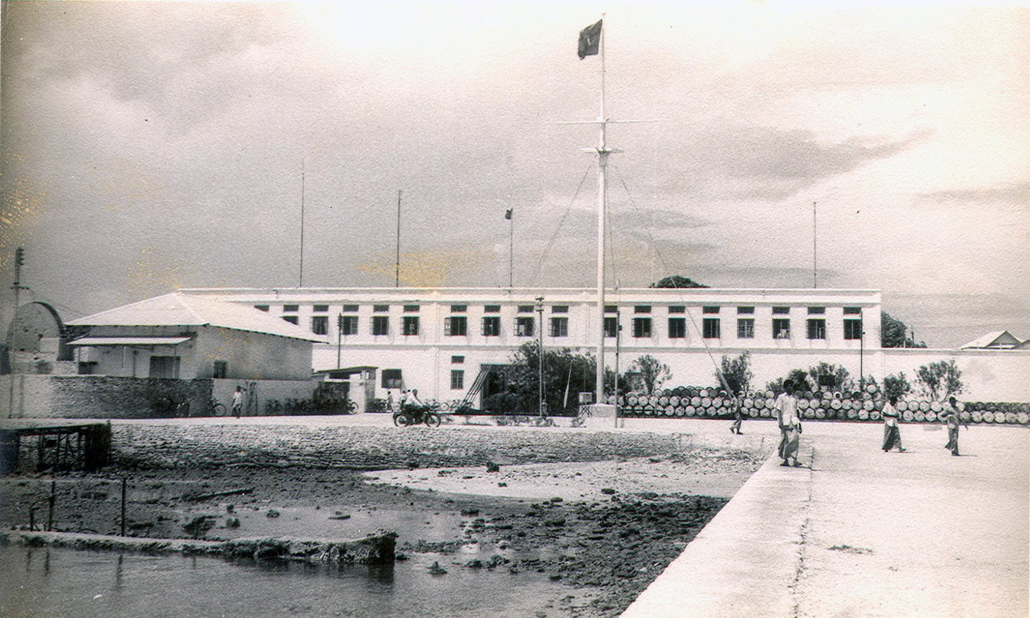
Badeyrige is in the background. Many government offices operated from Badeyrige until the 1980s. The flagstaff in the foreground is called Koattey which served some ceremonial functions. The flagstaff was removed during the presidency of Ibrahim Nasir. It was replaced in the next presidency by Maumoon Abdul Gayoom, albeit different in form and function. Many well-wishing visitors had recommended the government to remove the shabby buildings in the foreground as they were eyesores. Two features incorporated in the building would become standard building fixtures for the next 70 years. The first is the concealment of the roof by raising a short parapet wall on the facade. The next is the use of two simple cornices as decorative features.

The two features of hiding the roofs by raising the facade above roof line and the use of simplified dual cornices were common in the government buildings of the time. These features continued to be used until about 1980s. Three other buildings worthy of note are the Government Bodu (Big) Stores, The Customs Building and the Prime Minister’s Office. All three were on the waterfront.


Ibraaheemiyya is the name of the former Customs Building before the office was moved to the North West of Male’. This building is named after Amin’s grandfather who built it during the rule of King Shamsudhdheen III. On the left of the building is the main gateway to the “city” which was upgraded by Amin from a large gate to remotely resemble a Roman triumphal arch.

The two storey-building on the left played a major part in the history of the Maldives. Originally built as the Customs, in the mid-20th century it was the Office of the Prime Minister. I remember seeing the building when I was very young. The gateway to Male’ can be seen on the right. During Nasir’s rule, he placed an ugly clock tower atop the gateway.

The government Bodu Store was the building on the right in white. The site nowadays occupy part of the Maldives Monetary Authority. The building played a major role in alleviating the famine during the World War II. Before the government started buying fish, all exports of fish and other marine commodities was carried out by the resident Borah merchants who underpaid the sellers.

Another picture showing Ibraaheemiyya and the old Prime Minister’s Office. The gateway can also be seen. The two small buildings between the gateway and Office were the Customs Baggage Room and the Office for Organizing Food during the Great War. The common features are obvious. The streets are narrow and the lack of trees is striking. There was a perception among some locals until very recently that trees and grass give the impression of unkemptness and were systematically removed. Instead of grass, white sands swept clean and smooth were valued.

Majeedhiyya School buildings were constructed with skilled Ceylonese labour by Amin. The school hall called “Dhaarul Uloom” [literally house of knowledge] was the largest roofed assembly area in Male for over forty years. For nearly five decades, the past students of Majeedhiyya were active in the upper echelons of society as administrators and technocrats. I was in the school for nearly 19 years altogether, first as a student and then as a staff. This view of the school must be from the early 60s. I have no recollection of seeing the school in this view. In the 1990s, two architectural monstrosities were built on the Eastern side.
From the above photographs, the regular features of the buildings are patent: two storeyed, relatively small windows, cornices on facade raised above roof and built with crushed coral stone using lime mortar.
Amin was aware that the solution to the impending shortage of land in Male’ for development lies in inhabiting the two islands close by: Vilin’gili and Hulhule. In an article published in Government Gazette entitled Dare— From Male’ to Hulhule or Vilingili he noted that the solution to the congestion of Male’ lies in daring to establish settlements in Hulhule or Vilin’gili.
 އެކި ނުކުތާތަކުގެ މައްޗަށް، ވަކިވަކީން، ވިސްނައިލަމާ ހިންގަވާށެވެ. އެންމެ ފުރަތަމައިން، މާލެ ފުރިއްޖެކަމެވެ. އަލުން ގެއެއް އަޅާނޭ ތަންކޮޅެއްނެތެވެ. ސަރުކާރުގެ އެތައް ތަނެއް އެޅުމަށްޓަކައި، ހުސްބިމަށްވަނީ، ކޮންމެހެން، ބޭނުންވެފައެވެ. މަދަރުސާތަކުގެ ކުދީންނާއި، ކްލަބްތަކުގެ މެމްބަރުން، އަތްފައި ދަމައިލާނޭ، ހުސްބިމެއް އަމުދުންނެތެވެ. ބޭރުންދާ، ޓީމަކާއެކު، މެޗްކުޅޭންޖެހެނީ، މިންތައް ހަމަނުވާފަދަ، ކުޑަތަންކޮޅެއްގައެވެ. އަލުން ކާރުޚާނާއެއް ހަދާނޭ، ހުސްބިންކޮޅެއް، ހޯދުމަށް ދާންޖެހެނީ، ހުވަފެނުގެ ޖައްވެއްގެ ތެރެއަށެވެ. އެހެން އިބާރާތަކުން ދަންނަވަނީނަމަ، މާލޭގެ ހާލުގެ ދޫ، ގަދައަޑުން ގޮވަނީ، ހުސް ބިމަށެވެ. ތަނަވަސް ބިމަށެވެ. ސަރަހައްދެއް ނެތް ހުސްބިމަށެވެ. ދެންނިކަން، މަސައްކަތެއްނެތިގެން، މާލޭގައި އުޅޭ ޒުވާނުންނާއި، މެދު ޢުމުރުގެ މީހުންގެ މައްޗަށް، ވިސްނަވާލަ، ބައްލަވާށެވެ. އެފަދަގިނަ މީހުންނަށް ހިއްމަތާ އެކު، މަސައްކަތްކުރެވެނީ، ތިމާމެން، އަމިއްލައަށް، އެއްވެސް މަސައްކަތެއްނުކޮށް، އެހެންމީހުންގެ އެހީތެރިކަމާއެކު، ދިރިއުޅެވޭތޯއެވެ؟ އާދެ! އެއްގޮތަކުން ނުވިއްޔާ، އަނެއްގޮތަކުންނެވެ. ނަތީޖާއެއްގެ ގޮތުން، ވައްކަންކުރުން ހައްތަހާވަނީ ގިނައެވެ. ތަރުހީބު ދެވެނީ، ކަންނެތްކަމާއި ލޮޑުކަމަށެވެ.
އަޅުގަނޑު މި ވަކާލާތުކުރާ ފަދައިން މާލެއިން ބައަކު ގޮސް، އެދެރަށުންކުރެ ރަށެއްގައި، ވަޒަންވެރިވަނިކޮށް، ކުރިމަތީގައި ހާމަވެފައި އޮންނާނީ، ރަނުގެ ފުރުސަތުތަކެވެ. މަސްދޯނިތަކެއް ބަދެގެން، މަހަށް ދިއުމުގެ ސިފާގައެވެ. ފެހި ކުލާގެ ދަނޑުތަކެއްގެ ގޮތުގައެވެ.
Thus Amin not only had the vision to foresee the solution to the congestion of Male’, he had articulated his vision in no uncertain terms.
During Amin’s era the architectural and historical buildings remained the same. However, the next era would bring a sea change to the urbanscape of Male’.
Nasir’s Era
On 21st August 1953, Amin was deposed in a coup, led by his Vice President with the participation of Nasir including others. The monarchy was re-established. Soon after, Nasir rose through political ranks to become, first the Prime Minister and then the President from 11th November 1968 to 10th November 1978. His period of influence, and the era spans from 1953 until 1978. This period will be called Nasir’s era for discussion. Nasir’s era encompassed the post-War boom years.
No one in the history of the Maldives contributed more to the urban mess of Male’ than Nasir in his about 25 years of rule. Additionally, the destruction of heritage architecture during his time is beyond comparison. Eyewitnesses noted the following:
-
- Streets open to the beach during Amin’s time were blocked by allocating plots of land for homes, not only spoiling the view but also preventing cleansing breezes flowing onto the streets.
- Nothing was done to make newer broad roads across the island leaving the previous street layout as it was. There were vacant land during his years of rule in Male’ but no circular streets were made to prevent the rough grid – more accurately the random – layout of ancient streets.
- Existing streets were narrowed when it continued to developing areas. For example, the Southern end of Chandhanee Magu is much narrower than the older Northern side.
- Amin had made open green areas which he called Fehi (green) near each ward office (avashuveri ge). Notably, there was a park with a running fountain where Nooraaneege now stands in Majeedhee Magu. Each ward also had a sports ground. The junction of Chandhanee Magu with Majeedhee Magu had a roundabout with the walls of corner boundary walls curved inwards into plots. Nasir allocated plots for homes in almost all of these spaces, including Maafannu playground. The four ward maizaange (an open gathering place for the public) were also removed.
Amin had travelled Europe including Paris and he attempted to recreate some of what he saw in Male’. The street leading from city gate to the city square was a boulevard with manicured gardens and casuarina topiaries called Ibraahimee Maidhaan. Imported planters adorned either side of the street.None of the Male’ garden areas of today in Male’ could compete with what he created using meagre resources he had. Nasir did away with all these turning city gate area into storage sheds. On the right of the boulevard he built a tall wall and made a jail with Quonset huts.
- Nasir destroyed several centuries-old mosques allocating land freed for residential plots. From many old mosque compounds, he gave residential plots almost right up to the mosque walls. He gave plots of land so close to the architecturally valued Eid Mosque that the boundary wall of one had to be later set back to prevent the smell of gifili distracting those performing the prayers. By this practice, many surviving old mosques now have entrances about six feet wide, with the mosque completely hidden from the street.
- He made a rule of allocating residential space from open front yards of private homes if they are large. This practice created hostility between the new neighbours.
- The new streets he built were equally narrow despite them being quite long. There was no relationship between length and width; for example, Buruzu Magu and Iskandhar Magu are about 20 feet wide despite their long length.
From the land freed by his practices, Nasir registered for himself land for new homes and shops. Not to be outdone, two of his closest ministers also took land for themselves, often from significant historical sites. How the site of French garrison in Male’, the Naaney Buruzu (Bastion) became the private land of one of his Ministers is a case in point. By the end of his presidency, Nasir had over 40 pieces of land in ideal locations registered under his name, most of which were confiscated by the succeeding Government.

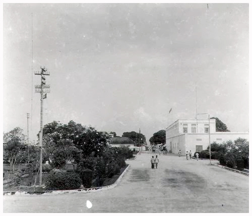
The Eastern view of Ibraaheemiyya and the gateway (triumphal arch) taken on 13th March 1972 when Queen Elizabeth II visited Male’. The incongruity of the clock tower above the gate can be appreciated, but that would require a sense of aesthetics.
Heritage architecture
Most of the heritage architecture from time immemorial survived until Nasir, the only exception had been parts of the official palace which had been burned down by marauders from Indian subcontinent a few centuries back. The palace had been rebuilt, albeit mostly with wood. The extant palace was over 300 years old.
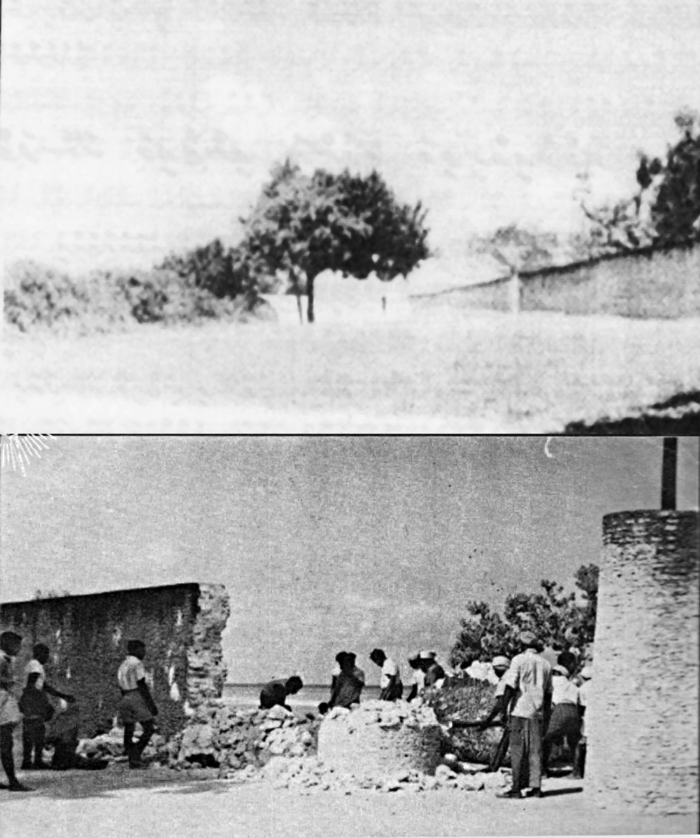
The fact that Nasir had removed the defensive wall without leaving a trace for posterity had already been made earlier.
Once the elected monarchy came to an end in 1968, he levelled the palace grounds turning it into Sultan Park. Nothing was left of the palace except for the Usgekolhu. During Nasir’s period of prime ministership, he fell out with the reigning King, and created a Republic. Perhaps, he decided to ensure that the monarchy never return by demolishing the palace. Interestingly, he was involved in creating the monarchy after abolishing the first Republic in a coup he participated.
Most of the historical artifacts were the old mosques. Nasir demolished several centuries-old mosques. Some he replaced with nondescript mosques of no architectural or historical value. He also removed the graveyards of many mosques with centuries-old tombstones leaving none for posterity. One old mosque, Kalhuvakaru Miskiiy was disposed off by auction.

A view of the palace from the junction of Fareedhee Magu and Chandhanee Magu looking East. The tall structure is the Mathige (High House) where the King had his office and throne.

A view of the Eastern side of Mathige. It was in three levels. The bottom level is the bastion which was filled with earth. The middle level is called “ban’galaathere.” Entrance to Mathige is from a balcony in the palace through a short bridge. Historical records indicate that Mathige was built by King Mueenudhdheen I who ruled from 1779 to 1835. Nasir began to demolish the building on 16th March 1969.

The last king, Mohamed Fareed, leaving palace in a procession. The building on his left is Mathige. Note the distance between the palace and Mathige. The entrance to Mathige is from the balcony on the left through a gangway (bridge).
New buildings
Nasir built four main buildings to accommodate government offices: Central Building, Faashanaa Building, Office of the President and the Office of the Prime Minister. He also built a girl’s school, Ameeniyya and extended Hameedhiyya School renaming it after himself to Naasiriyya Motessori School. Majeedhiyya School was also enlarged with nondescript extensions. There were few other minor buildings. He was also responsible for dividing the Eastern inner harbour of Male’ by building a causeway to the outer breakwater near Funadhoo side. He also started reclaiming land from lagoons. Nasir had many shops and homes built for himself but these are not described herein.

Nasir built a shop for each atoll on the Northern side of Male’ waterfront. The plot of land for each atoll was about 25 feet by 100 feet. The shops were rented out and I believe the proceeds were channelled to atoll accounts creating an income stream for atoll development. A wide pavement was in front, which had been narrowed to widen the streets in recent years. In Maumoon’s Era, the extensive backyard was reallocated to other parties leaving only the shop for the atoll. At least in some cases, the shops were rented out to middlemen who then re-rented the shops to actual users. Middlemen were invariably “friends” of the minister in charge of atoll administration.

For the growing administration, Nasir built four buildings to house government offices. This one is called Faashanaa Building. A similar building known as Central Building was on Ameer Ahmed Magu facing Badeyrige. On the right of the picture, is Koattey where presently there is a new flagstaff. Opposite the flagstaff on the Eastern side was the first power house. Faashanaa Building was demolished when the Ministry of Atoll Administration was abolished in a set of reforms to decentralize administration of atolls made by Maumoon in his last term, 2003 to 2008.
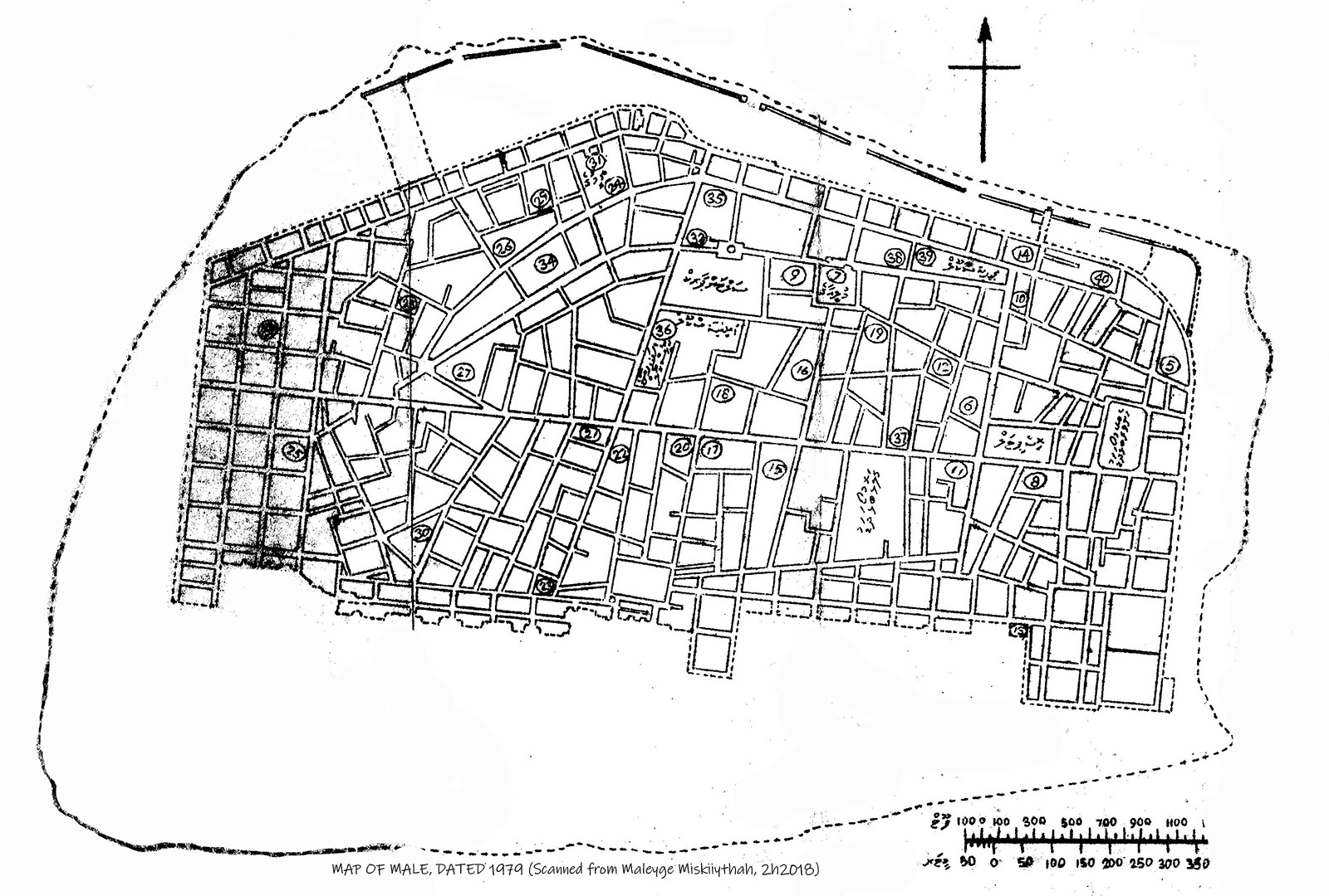
After the map shown earlier, this is the only detailed map I have seen of the intervening years from 1920 to 1979. I well remember the development of Male’ to this state from the early 1970s. Note the lack of streets from the North to the South. The newer roads were quite narrow for their length. The layout of the town was made worse in Maumoon’s era after blocking the streets leading to the sea. Nasir did not seem to have the vision to appreciate the significance of widening streets. I have been told that during Nasir’s era, a streets Amin made in one island was narrowed by allocating residential plots from the street.
In urban planning, it is usual to have two circular roads, one within the other with spoke roads joining the circular roads. One of the best designed towns is said to be Curitiba in Brazil where urban students from Europe still visit to study the thoughtful layout of the town.
Summary
In this article on the urban planning of Male’, I have outlined the major developments to the urbanscape within two eras, the ruling periods of Amin and Nasir. These two periods contrast one another profoundly. Amin widened and straightened the streets creating parks and parkland. Nasir did away with them creating narrow long roads leading to slums. Most of the historical structures remained intact until Nasir assumed power in the 1950s. By the end of his rule, Male’ had been almost devoid of ancient graveyards and mosques. The island had become very congested, streets narrow and long. The conditions were to exacerbate in the next few decades (See Part 3).


There are other detailed maps of Male, but many have faded: https://maritimeasiaheritage.cseas.kyoto-u.ac.jp/manuscript-viewer/map-2/
Do you really think the problem of Male’ congestion is about city design?
Decentralization. That is what is needed to de-congest Male’.