
The Making of Male’ Urban Mess: Part 1: From prehistory to the 1920s

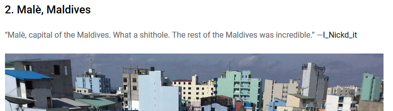
Recently an overseas commentator described Malé as a “shithole” [Link embedded in the image below]. That is a term many town planners would see as apt and one that is close to the imagination of many Malé residents. How did we sink into this state of urban mess and what can be done to decongest and decontaminate Malé so that it becomes liveable again? Did poor governance lead to the present urbanization mess?
Geomorphology and settlement of the islands
There has been a number of attempts to date the formation of the islands of the Maldives. Some studies sought to drill the reefs of some islands and use radio-carbon dating to suggest theories and dates of the formation of these islands. Perhaps, the first study of this type was done by Mohamed Ali as part of his doctorate research (Reef island geomorphology: Formation, development and prospective of islands in Eta atoll, South Maalhosmadulu, the Maldives. Unpublished PhD thesis. The University of New South Wales, Australia, 2000, 344 p). While his interest was in Baa Atoll we are safe to conclude that the islands of both Male’ and Baa atolls are of the same geological age. The studies indicate that the islands were formed at least 4000 to 5000 years ago in the Holocene age—a rather recent time in geological terms. There are minor differences in the age of different islands, but we may say with certainty that Male’ was in existence 4000 years ago. These studies also indicate that earlier than 4000 years (between 4000 and 8000 yBP [year Before Present]), the sea-level was much lower reaching 14 metres below current level at its lowest. There are more details of the geomorphological history in this paper.
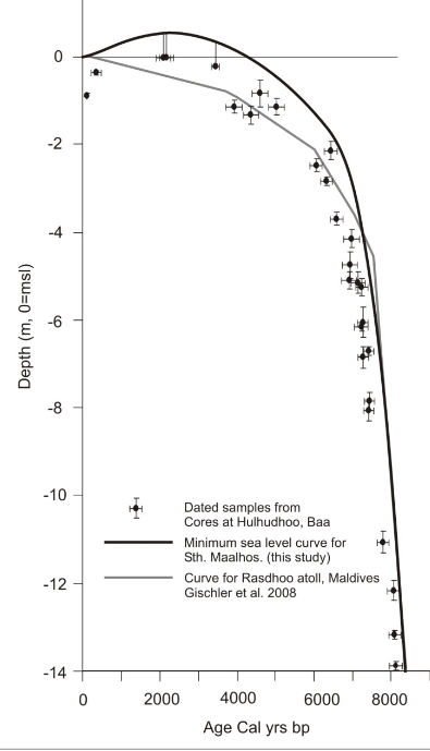
About 4000 years ago, the sea-level was much lower than the present level. The lower sea level would have enabled people to walk across the islands of an atoll. A boat would still be required to travel across the atolls. Maldives could have been settled for more than 4000 years as the islands rose gradually with the sea level rise.

A skull excavated from Jericho, Palestine, had cowrie shells in the eye sockets. The cowrie shells used seem to be of Maldivian origin. The skull was dated to be over 4000 years old.
Not long after the islands were formed, they were settled. Early settlers came from the neigbouring countries in boats. Boats have been in existence for over 45,000 years and sailing was well established 4000 years ago even in neighboring countries. In Sri Lanka, in Attanagalle oya, a boat found with a capacity of 150 passengers was dated 3500 BCE. A boat wreck discovered with a cargo of trade goods near Sri Lanka was estimated to be 2000 years old. Maldives is in the “maritime silk route” of the early sea-farers. Thus, it is reasonable to conclude that the Maldives was initially settled by people from neighbouring countries several thousand years ago. A funeral mask, with possibly Maldivian cowrie shells discovered in Jericho [Palestine], was dated 4000 year yBP. Recent genetic studies confirmed that the people generally came from South Asia. However, it was discovered that there was a strong gene flow from the Middle East. Interestingly, there are indications from gene studies that there is a female genetic flow from the Middle East. This discovery was later found to be untrue. These findings are corroborated by linguistics studies as well.
Early development of Malè
For as long as we know, Male’ has been the capital of the Maldives. The King or Queen and almost all nobles resided in the island. This fact was borne by the heritage architecture which survived into the middle of the 20th century. Almost all the significant monuments were located in Male’, including former palaces.
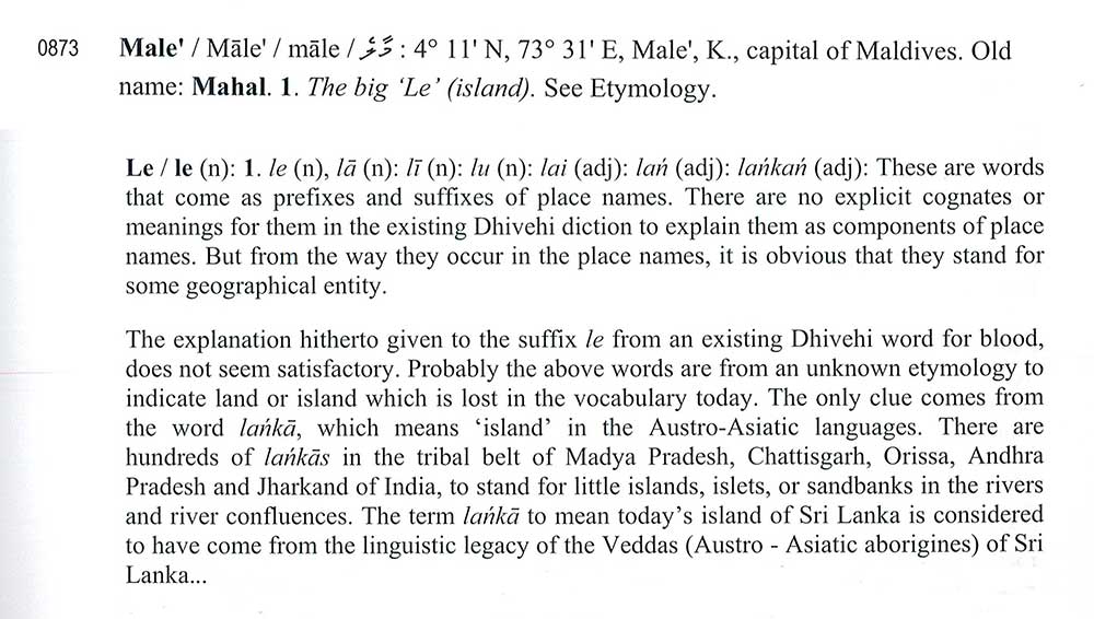
Why is Male’ called Mālé (as pronounced)? According to two scholars who delved into the etymology of our island names, the actual meaning is lost in the fog of the past. The following is from their book: Etymological Dictionary of Maldivian Island Names. It appears to suggest that Malé means big island though the authors are not sure. Young and Christopher who visited the Maldives in 1835 noted the following: “On the return of the Benares to Male’, or King’s Island, (so called from the residence of the Sultan,)…” in the memoir suggesting that Malé is known so because of its prominence.
There are only very few islands which are larger than Malé in the Maldives and, in that sense, it makes sense to call the island [maa-lé] big island. The island may be called so because of its significance rather than size. Malé is also, somewhat, in the middle of the archipelago close to a large number of islands and well-placed for sailing to and from Sri Lanka making it appropriate for the seat of government.
The area of Malé has been increased through reclamation of the lagoons surrounding the island. As naturally formed, the island has an area of just about 1 square kilometre. In 2017, the land area of Malé, calculated using GoogleMaps, is just under 2 square kilometres. TheGuardian gives the area of Male’ as 5.8 square kilometres which is far off the correct value. This report gives the area as 1.952 square kilometres which is closer to my calculation of 1.98 square kilometres. [The latest statistics give the resident population of Male’ as 133,019 which gives a resident density as 66510 per square kilometres. This statistic is from 2014 census. Interestingly, this density places Maldives as almost the tenth most densely populated area of the world.] A livable urban population density may be considered as about half of the current density. From an architectural and sustainable point of view, this density is about 25,000 per square kilometre. This means that decongestion is the only long-term solution to the Malé urban mess.]
Possibly, the best description of Male’ in architectural terms is given by Young and Christopher in the Transactions of the Bombay Geographical Society (from 1836 to 1838).

Although, Young and Christopher noted that “the town is regularly laid out, the streets being straight and long, running in parallel lines, intersected by others at right angles” this is indubitably not so. I regard this error due to the shortness of their stay and the lack of proper spatial awareness when walking on the streets. They must have thought that Male’ was laid out in the pattern of Roman town plans reminiscent of gridirons. A detailed map from the early twentieth century shows that there was little or no planning and the streets were not straight. The streets were straightened in the 1920s as historical documents attest to.
Earlier drawings show that the urbanscape of Male’ is somewhat like an unplanned village with streets defined by wooden posts without permanent walls except, perhaps, around Hukuru Miskiiy. The drawings below are from the book by Francois Pyrard who was shipwrecked on 2nd July 1602 around Goidhoo.


Early 20th Century Malé
The unplanned urbanscape of Malé, as it was in Pyrard’s time continued until the beginning of the 20th century. The reason for this state of affairs is the lack of exposure to overseas towns and education among the ruling class. This point was made by both Pyrard and the English mariners (Young and Christopher). The latter two make the point that the viziers have never been overseas and have, thus, a narrow view of the world. But, education itself is not sufficient to improve urban planning, as we shall show later.
At the beginning of the twentieth century, the most significant construction is the defence wall around Malé during the reign of King Imaadhudhdheen I (1620–1648). Forts were attached to the wall at strategic points. The wall enclosed Malé from three sides. The first three-storey building surviving until today must be the Usgekolhu built by Muhammad Imaadhudheen VI reportedly for his Egyptian wife-to-be. He ascended the throne by deceit in 1893 and was deposed in 1902.
The most descriptive account of the urbanscape of Malé was given by HCP Bell in his Monograph (The Maldive Islands. Monograph on the history, archaeology and epigraphy, 1940). The book includes the oldest detailed map of Malé though dated 1922. On the subject of municipal improvements (p. 61), Bell notes:

Bell speaks of the improvements made to the urbanscape within four categories. The esplanade he noted is marked in the map in the book. This esplanade was where Islamic Centre now stands. The esplanade included a much larger area then the premises of the Centre.
The other improvement he noted, Bodu Magu, is now called Majeedhee Magu. He describes Majeedhee Magu as clean. In fact, this state of cleanliness continued until mid-1980s when households used to consider as their first responsibility to sweep the streets on starting the day.
How knowledgeable Bell was may be gleaned from his familiarity with French and Latin, not to mention Haussmann planning—the architect who made Paris the city of lights and love. The Maldivian Haussmann was Abdul Majeed who was the Prime Minister when Bell visited Maldives for the final time. Before Abdul Majeed, none of the streets were straight nor wide enough for the growing population. That Abdul Majeed must be given credit for widening and laying the streets straight may be deduced from the memoirs of the Royal Scribe: Malim Moosa Maafaiy Kaleygefaanu. He notes the following in connection with having to shift his house to widen and straighten Chaandhanee Magu, then called Machchagolhi Mai Magu.

The third point Bell notes is the construction of modern buildings. Bell, as any historian would, lament the destruction of architectural heritage to construct so called modern buildings. The French term trop-de-zèle mean with too much zeal. He was, in particular, disappointed with roofing-sheet buildings built next to or near Government Bodu Stores (now MMA) and Medhu Ziyaaraiy. Unfortunately, in 2017, ninety-five years after Bell wrote it, heritage destruction continues unabated through the eras of Nasir, Maumoon and latter rulers. I have seen the utilitarian sheds much like hangars on the Northern waterfront blotting the picturesqueness of the promenade. The picture below shows the waterfront. The so-called New Palace is Mulee-aage, known as the Presidential Palace in the middle years of Maumoon’s presidency.


The waterfront view was blighted by the erection of industrial roof-sheet clad storehouses well into 1980s. Bell laments the unsightliness of these in the 1920s.
The final point which Bell points to is water and sanitation. By 1970s, fifty years after repeated admonition by overseas health professionals, the two water tanks built in Maafannu and Henveyru were the only means for public access to water. Water was distributed from these above-ground small tanks only on certain hours of certain days. It is not a daily water supply. Additionally, no water tanks were built in Machchangolhi and Galolhu. The state of veyo (or tanks for bathing) are aptly described by Bell below and no more needs to be said. In an island, surrounded by sea, the construction of these bathing tanks must be because of a religious significance of the days of ignorance for they have no place in Islam. They are found in Sri Lanka. The tanks were filled with sand in the 1960s.

In spite of the urging of the Sri Lankan government and visitors, there were no public conveniences in Malé till the 1970s. The one that was built in the 1970s were located in the space now occupied by the offices of the maritime operations of the defence forces. The sewer from this toilet block emptied into the inner harbour filling the picturesque promenade with the smell of filth. This state of affairs continued until tourism started in the 1970s and the government laid the first public sewer of about 1000 feet in the promenade. These cases showcase the state of urban planning of the time.
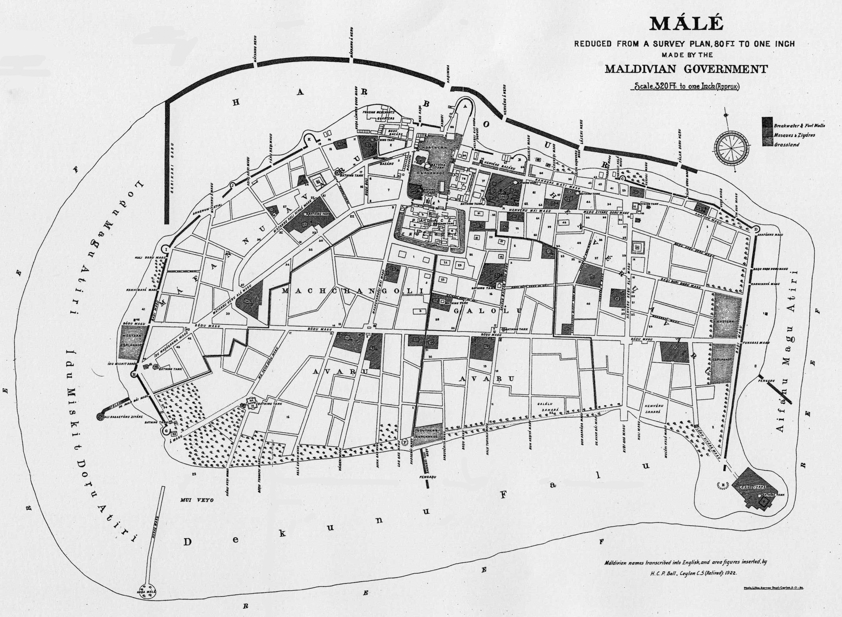
The first detailed map of Male’ was drawn by the Maldivian government for Bell in 1922. This image is quite large and may be viewed in full size by clicking it. The extensive defence wall can be seen. The other points of interest are the large green areas, veyo (bathing tanks) and large mosque yards. At this time, Abdul Majeed had made both the Chaandhanee Magu and Majeedhee Magu straight and wide. As can be seen, the layout is not at all grid-like nor Haussmann-like. There is no systematic layout of streets.
Summary
A point of interest is that Bell noted that Male’ was over-populated in 1922. His book gives the population of Male’ in 1921 as 6127. If he were alive today, Bell would have been astonished to see more than ten times that number of people living (or rather struggling to survive) in the same limited space.
Additionally, Bell noted that the
“Island is “far too over-crowded,” with its superfluity of graveyards and other curtailments of available ground. “Migration or other measures (such as utilizing neigbouring Islands of Malé Atol North and South), for relieving the congestion must inevitably be resorted to in the not very distant future.”
How accurately Bell had predicted what should come to pass is astonishing. In the 1970s, the graveyards were turned into housing plots and nearby islands of Malé were utilized for housing. What he has not foreseen is the reclamation of Malé lagoons doubling the land area.
In this first part of the Making of Malé Urban Mess, I have outlined the historical development of the urbanscape from prehistory to the 1920s. In general, Malé’s urbanscape remained unchanged until the beginning of the twentieth century, though the island must have been inhabited for millennia.
At the beginning of the twentieth century, the island was more like a settlement with few significant buildings. The palace, some mosques and the residences of chiefs were, however, noteworthy. The streets were not straight or wide lacking any semblance of planning. In part, this was due to the lack of exposure and education of the rulers. By early 1920s, there were attempts to properly lay out main arterial roads.
The main issues facing Male’ at the end of 1920s was the lack sewerage systems and water—basics for healthy living. Sadly, this state of affairs was to continue for the next 60 years.
The final part of this essay outlines the development or misdevelopment of Male’ up to the present time.
Acknowledgements: The extract from the Etymological Dictionary of the Maldivian Island Names was provided by Nazim through Shāzinā of Dhivehi Bahuge Academy.

Well researched piece of writing that provides a glimpse of the Male’ urbanscape then.